
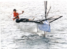
Here's a link to the iWindsurf.com wind observation archives for the month of July. I finally found a photo of the Stokes sailing in the 29er's nationals that I referenced in this post. The comment Gordie made was that it was "honkin'." Well, the data shows winds on Friday between 12:15 and 5:30 to be 20 to 25 mph, with gusts another 5 above that. On Saturday, the winds were averaging a little less than 20 mph, gusting to about 23, again with pretty consistent strength between 10:30 and 5:30. On Sunday, the winds were about 17 mph all day with the highest gust to be less than 25mph.
Looking at the wind graphs for the entire month of July I see these three days to be about average. The iWindsurf.com site, under a tab about "local info" says this about our venue (remember Stevenson is across the river from Cascade Locks, but is referring to our sailing waters.)
Stevenson Overview
Stevenson is without a doubt the overall windiest spot in the Gorge as it receives both moderate westerlies and strong easterlies year round. Best sailing conditions generally develop in the early fall w/ the combination of strong east winds (30-40 mph) and warm river temps. Several launch sites are available near this sensor w/ Bob's Beach being the most popular. Bob's features grass rigging, a small parking area and covered changing facilities as well as an easy launch into the river. Remember that wind and current are moving the same direction on an easterly so it is necessary to point hard upwind on your initial reach. Parking is generally not an issue as a large number of overflow spots exist to the east. Two additional launch sites lie just to the east of Bob's and offer decent launching w/ less crowd.
We can forget about the easterlies since they're a fall-winter phenomenon. Referring to their wind sensor they say:
Sensor NotesGoogle maps shows a satellite photo of Stevenson and by dragging the window south the pier is clearly visible (my guessing somewhere around a potential leeward mark location.)
Excellent sensor position for both its west and east wind indication, gauge is located at the end of a pier jutting about 200 ft. into the river. Located about 250 ft. east of Bob's Beach and 1/2 mile west of the Boat Ramp. The site is somewhat shadowed on NE'erly winds but the overall effect on windspeeds is minimal. This location is generally regarded as the windiest spot in the Gorge as far as number of days better than 5.0 m's (both east and west wind) is concerned.
View Larger Map
And lastly, here's a sketch showing the relative locations of Stevenson, WA (point A) and Cascade Locks, OR (point B). I've indicated the launch beach and the wind sensor. Also, I've drawn in a one mile segment to give a sense of the course length. With a SW wind the leg would be along the river axis, but most of the breezes recorded on the archive graphs are west or westsouthwest, so we will be sailing slightly off-axis. Perhaps someone familiar with the race committe practice at this venue could enlighten me. Doogie?

3 comments:
Joe,
The Stevenson/Cascade Locks part of the Gorge is considered the windiest part of the Gorge because it has wind when other areas of the Gorge do not. It's not referring to wind velocity. With the exception that in the winter the easterlies are really strong here. It's very rare that Cascade Locks has stronger westerly winds than the central or eastern Gorge.
As for direction, it can shift around a bit as the day progresses. It's no different than other venues; clouds influence the direction, velocity changes can swing it around too. How does the race committee deal with it? They move the marks around as necessary. The good news is it doesn't take very long to shift marks around.
Andy
Thanks for the feedback. Can you provide daily updates during the Nationals for us right-coasters?
Sure. I'll do my best.
Post a Comment